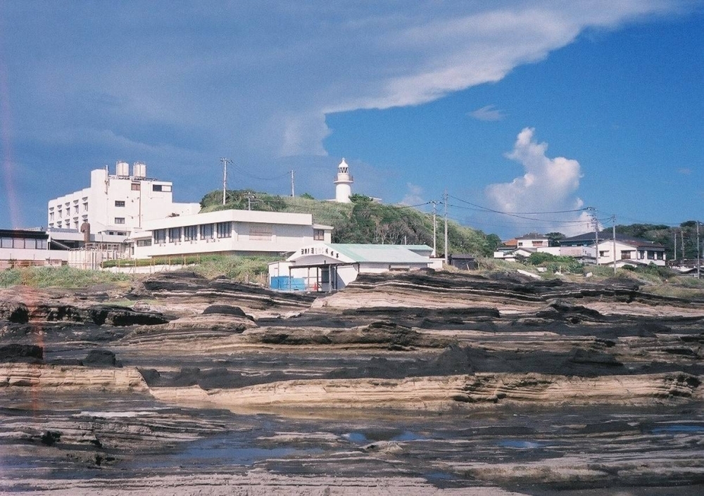
In the summer of 1689, the poet Matsuo Basho departed from the port town of Sakata in Yamagata Prefecture, embarking on a northward journey along the Sea of Japan. His destination was Kisakata, an inlet adorned with around 100 small, pine-covered islands, renowned for its natural beauty since the Heian Period (794-1185).
Kisakata marked the northernmost point of Basho’s legendary 160-day on-foot exploration of the Tohoku region, a pilgrimage that gave rise to his seminal work, “Oku no Hosomichi” or “The Narrow Road to the Deep North.” This poetic diary stands as a literary masterpiece from the Edo Period (1603-1868).
Captivated by the magnificent lagoon, Basho composed a haiku, comparing the nebu (mimosa tree) flowers to the gracefulness of a slumbering Seishi, or Xi Shi, one of the Four Beauties of ancient China:
Kisakata ya (Kisakata —)
ame ni Seishi ga (Seishi sleeping in the rain)
nebu no hana (Wet mimosa blossoms)
Today, the verses of the renowned poet and others are the sole remnants of the once-famous coastal landscape.
“The scenery Basho admired vanished after a magnitude 7.1 earthquake struck the region on July 10, 1804,” explains Kazuki Saito, a local historian and official at Nikaho’s cultural properties protection division, the city in Akita Prefecture encompassing Kisakata.
“The seismic event caused the seabed to rise, transforming the ‘islands’ into formations surrounded by land instead of water,” he adds. “It’s reminiscent of what occurred in Noto.”
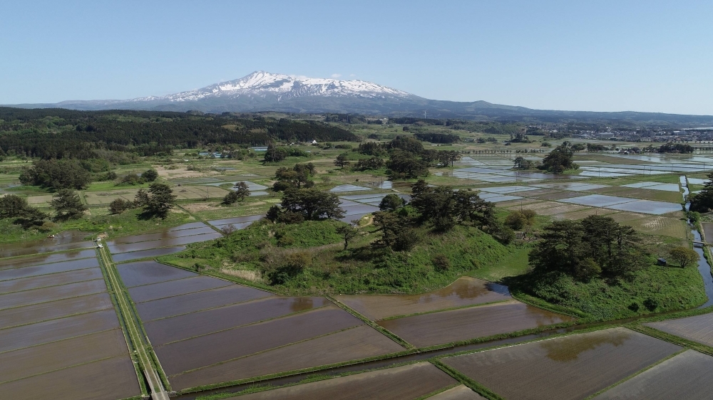
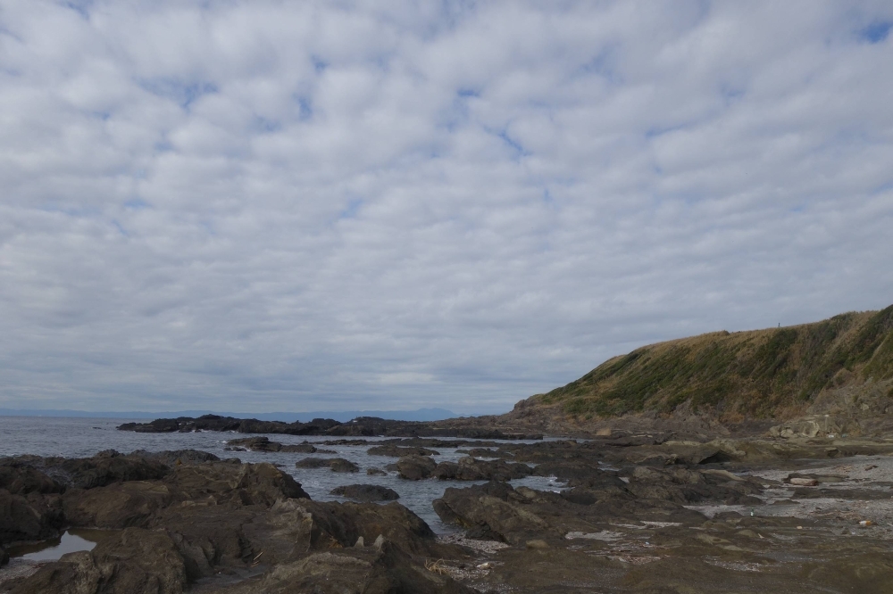
An earthquake that hit the inlet of Kisakata, Akita Prefecture, in 1804 caused the seabed to rise, and islands are now scattered among rice paddies. | COURTESY OF MOUNT CHOKAI & TOBISHIMA ISLAND GEOPARK PROMOTION COUNCIL OFFICE
Saito is referring to how a 7.6 magnitude earthquake that shook Ishikawa Prefecture’s Noto Peninsula on New Year’s Day caused the ground to rise up to 4 meters in some areas along its scenic coast. This devastating event impacted the region’s fishing industry, revealing shells, starfish, and other shallow-water marine fauna and flora.
The calamity serves as a stark reminder of Japan’s position on the volatile “Ring of Fire,” situated among four major tectonic plates, and how the country has been shaped by seismic activity, volcanic eruptions, and often lethal convulsions.
Since separating from the Eurasian continent 20 million years ago and forming the Sea of Japan, Japan has constantly faced nature’s seismic uncertainties, resulting in ongoing transformations in its landscape and ecology.
The unpredictability and lack of control over the environment have cultivated a unique Japanese perspective that embraces transience and impermanence.
During his northern journey, Basho is believed to have encountered the philosophy of “fueki ryūkō,” encapsulating the constant evolution of nature over time and seasons.
“The islands of Kisakata are now more like mounds surrounded by rice paddies,” notes Saito. “But during April and May when the fields are filled with water in preparation for planting rice, a view reminiscent of the old Kisakata is resurrected.”
Unprecedented Uplift
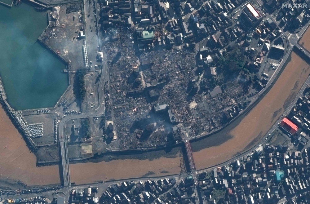
The earthquake off Noto Peninsula’s northern coast on Jan. 1 not only destroyed homes, triggered fires, landslides, and tsunamis, claiming 238 lives as of Feb. 1, but it also revealed a phenomenon unseen in the past century: massive ground displacement.
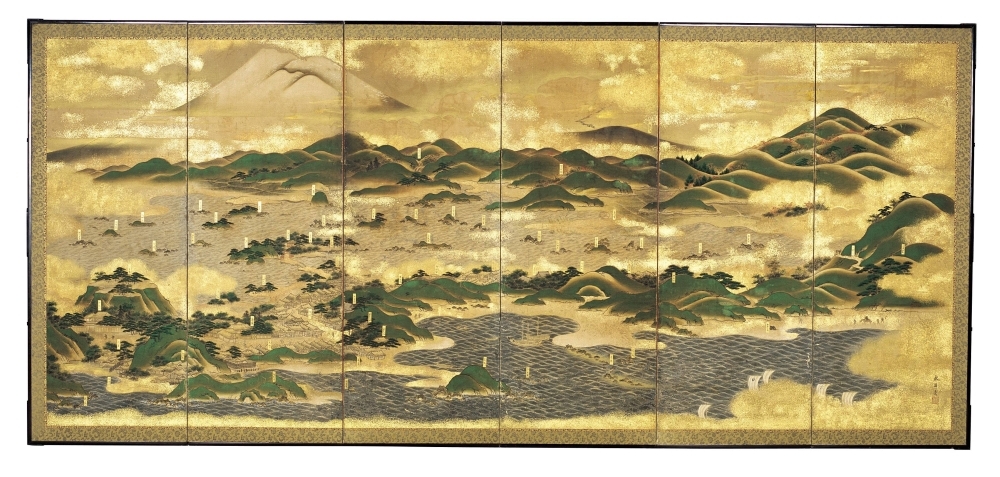
A painting on a byobu (folding screen) depicting Kisakata before the earthquake. | COURTESY OF KISAKATA FOLK MUSEUM
“The extensive uplifting likely occurred during the intense shaking,” explains Tatsuto Aoki, an associate professor at Kanazawa University engaged in fieldwork in affected areas.
“It must have been an unusual sight for those present, witnessing the ocean recede before their eyes, unaware that the ground beneath them was swelling up.”
An analysis by the Geospatial Information Authority of Japan, utilizing data from the Advanced Land Observing Satellite-2 (Daichi-2), revealed an uplift of over 1 meter across a wide area of northern Noto. Sections of the western part of Wajima city experienced elevation by up to 4 meters.
Meanwhile, a report from the Association of Japanese Geographers estimates that the quake elevated land along 90 kilometers of the peninsula’s coastline, thrusting the seaboard outward by approximately 240 meters in Wajima’s Monzenmachi Kuroshimamachi district.
Aoki, an expert in physical geography and regional disaster prevention, has been traversing hazardous roads to the peninsula from Kanazawa, recording the quake’s impact.
“In a word, I’m shocked,” he says. “The scientist side of me is overwhelmed by the immensity of the natural phenomenon, while as a local resident, the dramatic change in scenery is heartbreaking. I’m still not able to process these emotions.”
Aoki notes that ground displacement of a similar scale, or perhaps even larger, was observed during the 1999 Jiji Earthquake in Taiwan. However, an upheaval of this magnitude has not been witnessed in Japan “for at least 100 years,” he adds.
“There will be a long-lasting impact on local fisheries, communities, and the environment,” he continues. “While Noto may appear remote and secluded, it has a vibrant history, and its residents have lived on their land for hundreds of years, relying on its plentiful seafood not only for their living but also as an important communication tool.”
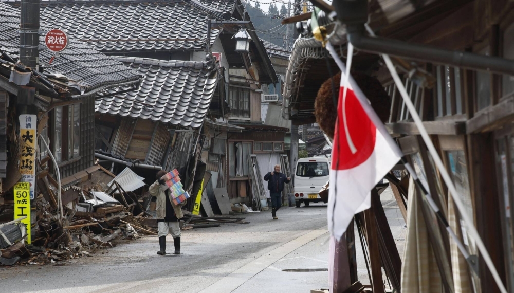
Burned houses in Wajima, Ishikawa Prefecture, on Jan. 2. Japan is home to around 10% of the world’s active volcanoes, and 18.5% of all the earthquakes across the globe happen here. | MAXAR TECHNOLOGIES / VIA AFP-JIJI
Ishikawa Prefecture ranked 16th in the nation for catch volume in 2020, with fishing concentrated on the Noto Peninsula known for its rich fish reefs. However, a prefectural survey revealed damage to breakwaters, wharves, and waterfront roads in 60 out of 69 fishing ports after the earthquake.
Despite reconstruction efforts, the region is grappling with an aging population, with 43.4% of Noto Peninsula residents aged 65 or older, significantly higher than the national average of 29.1% according to the 2020 national census.
Scientists anticipate studying the long-term impacts of the seismic activity on the region’s geography and topography.
“When the ground lifts, the flow of rivers, streams, and groundwater shifts over a five- or 10-year period, as well as the coastline and even inland terrain,” explains Aoki. “That also has a direct impact on organisms living in the ocean and rivers of affected zones.”
Japan, the most seismically active country globally, records about 18.5% of all earthquakes worldwide. In 2021 alone, over 2,400 temblors were recorded, with the archipelago situated at the boundaries of the Pacific, Philippine Sea, North America, and Eurasia tectonic plates.
“The Japanese archipelago was created by active uplift and subsidence and repeated earthquakes such as the recent one that befell Noto,” says Hideaki Goto, an associate professor at Hiroshima University who led a survey of crustal movements following the disaster. Goto estimates the Noto Peninsula expanded by about 4.4 square kilometers due to the earthquake, causing the ground to tilt, lifting the northern portion while lowering certain areas in the south.
Layers of rock on Jogashima island in Kanagawa Prefecture in September 2020 | CHRIS RUSSELL
“Over the span of 120,000 to 130,000 years, the Noto Peninsula has witnessed recurring seismic activities, including earthquakes, ground uplift, and subsidence, contributing to the formation of its current landscape characterized by hills and terraces.”
At a recent symposium hosted by Tohoku University, seismologist Shinji Toda detailed that a network of active faults beneath the peninsula and the adjacent sea created a 100 km band, leading to the substantial seismic event.
Examining the geological features of the peninsula, Toda estimated that the seismic energy required for such significant ground uplift had accumulated over a period of 3,000 to 4,000 years.
Hideaki Goto emphasized that while the recent calamity was notable for its extensive ground displacement, similar seismic episodes are evident across Japan. He cited examples from various locations, including the Great Kanto Earthquake of 1923, a magnitude 7.9 event off the southern coast of Kanagawa Prefecture, which caused significant land elevation observed, for instance, at the southern end of the Miura Peninsula in Kanagawa.
The coast of Jogashima island in Kanagawa Prefecture. The rocks jutting out from the sea are remnants of past ground lift. | ALEX K.T. MARTIN
Tectonic Testaments:
Jogashima’s Geological Heritage On a clear day, the picturesque views of Mount Fuji, Oshima Island, and the Boso Peninsula unfold from Jogashima, a small island situated off the southern tip of the Miura Peninsula, approximately 70 kilometers from Tokyo.
This island, a magnet for tourists throughout the centuries, extends into the Pacific Ocean and has also been a wellspring of inspiration for the renowned poet Hakushu Kitahara. His creative influence is immortalized in the lyrics of the song “Jogashima no Ame” (“Jogashima in the Rain”).
Amid its cultural and natural allure, Jogashima carries tangible evidence of past seismic events, notably the 1703 Genroku Earthquake. The rocky beach and terraces along the island’s southern coast bear etchings of ground uplift, a silent testimony to the forces that have shaped its geological history.
Examining a postcard from 1918 reveals the transformation of a natural rock arch, known as Umanose Domon or Horseback Cave. Originally partially submerged beneath the ocean, this geological formation underwent a lift of approximately 1.5 meters during the seismic upheaval of the 1923 Kanto earthquake.
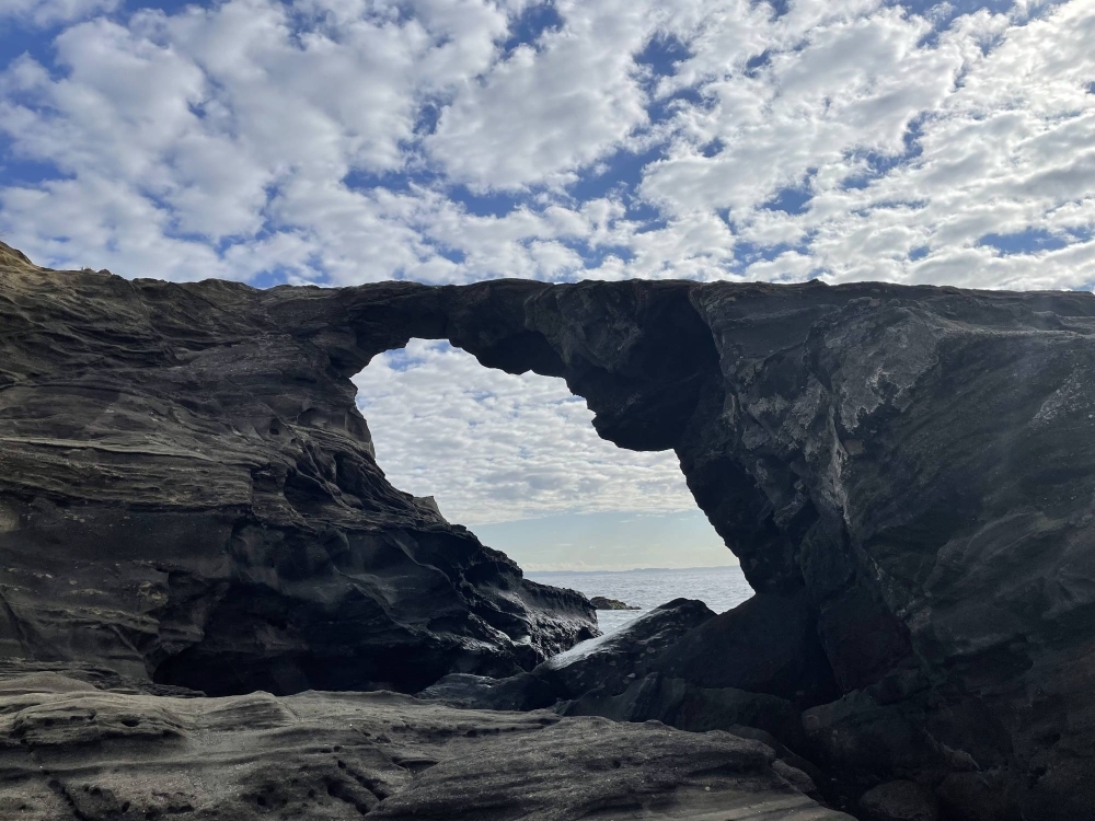
Umanose Domon, roughly translated as Horseback Cave, on Jogashima island in Kanagawa Prefecture used to be half submerged before the seabed was lifted up during the 1923 Kanto earthquake. | ALEX K.T. MARTIN
In fact, the earthquake caused the port of Misaki to temporarily elevate by approximately 6 meters. This unusual event enabled people to walk across to Jogashima for several days before the sea level gradually returned, attributed to subsidence caused by the lingering effects of the seismic activity.
Saeko Ishihama, a researcher at the Kanagawa Prefectural Museum of Natural History, notes, “The Miura Peninsula boasts numerous coastal terraces shaped by seismic activity. Among the oldest are remnants of the seafloor from around 120,000 years ago, discovered on a mound approximately 100 meters above sea level.”
In the 1973 best-selling sci-fi novel “Japan Sinks” by the late author Sakyo Komatsu, later adapted into a 2021 series on TBS and Netflix, the Japanese archipelago succumbs to the sea due to catastrophic earthquakes, volcanic eruptions, and tsunamis. While this fictional work underscored the geological risks confronting the earthquake-prone nation, Japan’s total landmass has actually expanded over time, driven by ground displacement from significant tremors, landfill initiatives, and volcanic activities, albeit gradually.
Ishihama highlights that the coastal uplift witnessed following the Noto earthquake, along with similar events documented in the Miura Peninsula and elsewhere, provides insight into the island chain’s formation over millions of years through seismic and volcanic forces. She emphasizes, “Without the potent forces generating earthquakes, Japan wouldn’t have come into existence.”